Tuesday, April 29, 2008
Potiential for Wed April 30th and mainly Thursday May 1st
Friday, April 25, 2008
Thursday April 24th 2008 Northern Kansas


Today we slept in at our hotel, and left at noon to radio shack to meet up with Verne. There we got lunch at a delicious Mexican restaurant, which Tony was in love with, but it was good stuff. After lunch we drove north just outside of Wakeeny and hung out on some dirt road next to cows mooing at us. We waited there forever it seemed, just looking at anything with the slightest bit of vertical development and saying over again how we liked the humidity and southeasterly winds. The discovery team drove by with their army of vehicles including the TIV and DOW. We ended up heading towards Hill City, when Verne Decided to head off west to just get in the middle of the cell that was to our west, and Tony later decided to do the same because He didn't want to take the chance of the storm coming at night. Skinner and I waited in Hill City for a super cell that developed to our west. We were able to intercept it on the front side and before it got dark we got to see the mesos and the wall cloud that was really defined. We were hauling to get there, we drove past Mike Umscheid and I decided to pull over to get some pictures of a meso, when there was one right on top of us. We noticed when we had no winds, it went dead silent. That was really creepy, and skinner started yelling "SHEP! Get in the car now! We have to go!" lol. We drove half a mile down the road and looked back to realize it was rotating above our heads back there. We pulled over next to Mike U and we got some pictures and video. We headed back to hill city because it was headed East-Southeast towards the city. The tornado Sirens were blaring throughout the town, and a ton of Skywarn, and other chasers and spotters were south of the city watching. I dropped my camera out of the car and realized it when i drove south down the road a ways. So we raced back just to the edge of the storm and saved my camera. We watched as it passed over hill city, we didn't see a tornado but it seemed very likely. Apparently there was a storm chaser and a deputy who saw the tornado but I don't understand how they could of at night in rain, and especially without being in danger to get to a point where you could see it.
Wednesday, April 23, 2008
Wed April 23 2008 E CO/ W KS


I hate my life
Eastern Colorado? or Texas?
two hands weighing just use your imagination........
sum it up I hate my life
Oh and by the way there will probably be tornadoes in Springfield MO
Monday, April 21, 2008
Potiential for Wed the 23rd
Thursday, April 17, 2008
Storm Chase Vehicle Ready


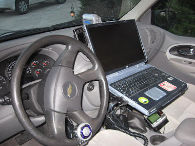

For all of you wondering what else I do
www.colighthouse.com
(This should become my chase vehicle someday)

Sunday, April 13, 2008
April 3rd South Central OK and Northern TX
(Video of the Large Hail we drove into this day will be posted in this Posting next week)


Thursday April 3rd 08
We left

We decided to wait for the initiation in Duncan OK. We saw development to our northwest but on the radar we noticed a cell
to our northeast, we considered chasing it but it exploded and
then just hauled northeast at 59mph.
We checked wx worx and we noticed a cell that was to our southwest moving NE at 35mph. This one looked promising and the other cell was gone. We wanted to intercept the southwest cell that was intensifying. We decided to try and get past it to get to the southeast side of the cell, so we had to get there quickly to avoid punching the core. We were making good time getting past it so we decided we might be able to even take a little bit of a shortcut. Well we were a little close so we ended up getting into the hail core. We ended up getting quarter to tennis ball size hail and my windshield is now destroyed, but we did get to see some decent structure and and a tad bit of rotation, we might have seen a wall cloud but there was a lot of evaportransportation so it was hard to see if there was anything. There wasn’t enough low level wind for that. We noticed a cell that was more isolated to the southwest and decided to hit that up since the northeast one was appearing to be clustered. We chased it and it had pretty much 0 surface wind besides the downdraft. It was in its dying cycle when we caught up to it.

This GVTS made some great photos and some entertainment as I was out dancing in the hail with my helmet on and then experiencing the RFD in my SUV. We got some good sunset updraft pictures of the cell shearing out and then we left hoping to get some lightning on the way to

(What use to be Pizza Hut)
Good Chase Potiential April 2nd 2008

Chase: S
Chasers: Ryan Shepard, Jon Skinner, Mark Farnik
Wed April 2nd 08
We departed to Elk City OK to stay with Skinner’s friend for a decent looking weather setup for Thursday in
April 1st 2008 Goodland Kansas
I woke up in my car in
March 31st 2008 OK & TX


Left Weatherford for far south central OK to a Moderate Risk for the entire southeastern part of Oklahoma, part of northern TX and parts of AR and MO. There was a 15% hatched area for tornadoes in the  local news stations, Roger Hill with silver lining tours and tornadovideos.net. The cell had good shear and reported a tornado at one point but I was late for that. It eventually went HP and died out, with the Squall line that was with the dominant Cold Front. On my way back west I had a close call when it got dark with some rotation in a cell that was apart of the squall line. I parked next to a couple fire fighters that were spotting. I showed them the areas of rotation to our west while emergency management got on the horn and told us to take cover. A few minutes later the rotation passed to our southwest so we were ok. I have to say though I did end up putting on my goggles and helmet because it was dark and the tornado risk had elevated. That same part of the county was tornado warned about 10 min later. It was time to go home, so I drove north watched some lightning and drove to

March 30th 2008 Oklahoma

Departed for  Also a huge turtle was crossing the road and told me to take my lectures to a convention of people who like lectures. So I stopped and filmed him walking, he decided to turn and confront me and get into an offensive snapping position. After watching these storms, enjoying the first thunderstorm environment since October, I got out of the way of the downdraft and got in behind the cell. As it got dark another cell that developed to my southwest had some decent sized hail, it was traveling in my direction and I didn’t want to punch the core of the cell I was on to my east so I waited out the hail in a carwash. Tony Laubach didn’t make it to cover so his windshield got spidered. I then found a hotel in weather ford and slept for the night in my trailblazer in the parking lot.

New Hail Guard Invention


I have been trying to create hail guards to protect my windows in large hail. I started making ones for the side windows using PVC, Plexi Glass and attaching them to the vehicle via metal straps nose clamped to the roof rack and strapped to the frame through the wheel well. Well after spending hours on creating these guards, the driving tests failed as the plexi-glass shattered anyway. When I get a chance I will upgrade to Lexan (Polycarbonate) Aims has been kind enough to en corporate my roof mounted hail guard for the windshield to their welding class. Still working on attaching the Mesh to the aluminum frame and painting it, aims should have the main steel attachments finished tomorrow! I will post a picture once its on the car!


(Windshield Guard)


