Sunday, November 15, 2009
Snow Fog
Sometimes after it snows its likely to have fog at night, when the moist air cools, and the air is calm. Here is a vid of fog the night after our last big snow storm in October.
Thursday, October 29, 2009
Interview on KFKA 1310 AM
Had an interview on KFKA this morning about Storm Chasers and my thoughts/experiences on the Balloon Boy incident.
Pre Halloween Heavy Snow Storm


Crazy October storm bringing up to 20 inches of snow so far! Before Halloween! This day years ago we had a tornado in Boulder that caused some damage, and were having a blizzard! The snow should continue but decrease throughout the day, however winds will pick up making visibility harsh. Hundreds of school closings still in effect, (except for my school, once again), DIA is handling the situation very well especially for a rare October storm. Most flights are either on time, delayed within an hour, and minimal flights canceled. A lot better than what most people expect at the Airport. Surprisingly I see a lot of people out driving around, there is a lot of people going shopping, I guess they are thinking of Christmas and they are utilizing the day off from the Snow Day Excuse. I saw one near accident today, a pickup took a turn too fast and went into oncoming traffic, goes to show that there is ice under that snow, be careful, your 4 wheel drive doesn't matter on ice. I-70 is closed! I have a flight at 7am to Ohio in the morning, I don't believe I will have much trouble.
Wednesday, October 28, 2009
Snow BRR

We are in the process of getting a lot of snow today
"Snow and areas of blowing snow. Temperature falling to around 31 by 4pm. Breezy, with a north wind between 15 and 22 mph, with gusts as high as 33 mph. Chance of precipitation is 100%. Total daytime snow accumulation of 4 to 8 inches possible."
All the While....
A Slight Risk in the Southern Plains! 5% Tornado!
 That's what happens when you have a trough look like this! I saw this thing a week out! I knew there would be some dumping going on here and some severe wx down south.
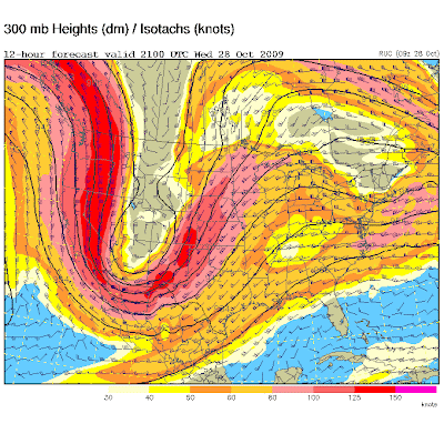
A look at this weekends Episode of Storm Chasers
Sean is trying to give away, what was my Dog for a while (RFD) I miss that puppy, he has a new home in California now
Sunday, October 25, 2009
Episode 2 Airs Tonight! 10pm EST
Watch Storm Chasers tonight at 8pm MST or 10 EST as we chase some amazing tornadoes in the panhandle of Texas and go through a big ordeal in the mud! I was driving TIV 1 for this entire episode.
Saturday, October 24, 2009
Texas Twins April 2009

This day was my most intense day driving TIV 1, with sisters and getting stuck in the mud it was quite a ride. I may make an appearance when our team meets up with TVN. Watch it this Sunday at 8pm MST.
Thursday, October 15, 2009
Wednesday, September 30, 2009


Monday, August 24, 2009
Vote for Storm Chasers on Youtube
Hey Discovery Fans,
YouTube just launched a new contest today - and we want to win it! From today until September 14th, users will have the opportunity to vote on their favorite fall television show previews right from YouTube. We're hoping you guys can help us out with some votes, and here's how!
Step 1 - Visit YouTube's new "Fall TV Preview" channel by clicking right HERE
Step 2 - Find the thumbnails for your favorite Discovery Channel shows. We've entered previews for three of our shows: Dirty Jobs, MythBusters and Storm Chasers. Here's what the thumbnails look like:

And how they will look on the Fall TV Previews page:

Step 3 - Click on the thumbnail to open up the video, and then give us a "thumbs up" vote (if you want to!)

That's it! On September 14th, YouTube will select the most voted on preview to be featured on their homepage for the day. Remember, you can vote multiple times so keep checking back to vote for your favorite Discovery shows and tell your friends!
Thanks so much for your support,
Soumik@Discovery
http://discovery.com
Friday, August 7, 2009


Thursday, August 6, 2009
August 4th Landspout Report

Spotter: Ryan Shepard (
Above picture was taken at

Location 1 (Blue) is my location at the time of the Land spout, and location 2 (Red) is the approximate location of the Land spout Tornado.
There was a lot of terrain west of Crawford, I had to get far enough west on 20 to be able to see the storm structure and ground. I got on a high spot for viewing the storm. It was dark, but the full moon and intensive lighting allowed for great night vision on the storm. The picture is not anywhere near what naked eye sight at night was able to see. Without lighting I was still able to see the tornado. The tornado formed very quickly, started from the ground as I saw a debris swirl, it quickly connected to the cloud base and lasted for 1-2 minutes. I called 911 at


(Picture

Wednesday, August 5, 2009
August 4th 2009


Today I thought was going to be a bust for Western NE as storms died and the skys cleared. I stoped in a resturant trying to accept defeat in central panhandle of NE. I finally decided that i came that far not to see anything so I wanted to go drive through a storm that would be coming out of WY/SD into NE. So I drove north and intercepted the storm moving across the border of NE/SD. I ended up between harrison and crawford NE watching the storm to the northwest cross the border. As I was watching this incredible lightning and meso in the distance, a landspout formed on the southern edge of the convective activity. It lasted for about 60 seconds and then disapeared as quick as it came, but was a solid obvious landspout tornado what seemed so close to my eyes. I was able to go home really happy this day when I expected a 400 mile drive bust. I didnt get any hail as I had problems with my driver side window so I decided to wait to punch the hail core. I did punch the core with no hail on the way home. My vehicle reached 100,000 miles this trip, and its a 2006 model haha. Almost hit about 3 deer on the way home.
Tuesday, July 21, 2009
July 20th 2009- NE/KS Supercell/Tornado


Today I left Cheyenne east on 80 to chase storms out near kimball, NE. By the time I got there the target storm had died but there was a couple more storms that exploded, these looked isolated and very robust. I continued to chase the southern cell that was headed from southwest nebraksa to northwest Kansas. I chased this storm over some great distance, when it got into Cheyenne County Kansas, that is when it went crazy. Softball hail was reported and then when I caught up to the storm it had mad wind shear and a rotating wall cloud. I stayed in front of it as it moved Southward through Cheyenne County, When I went south on 21 to St Francis I noticed it started to get rain wraped. When the road curved back east I got a bad feeling, especially the way the wind was blowing and the way the rain curtains were moving. I decided to not drive through the cell to get to the south in position. It was too dangerous, and I also didnt let a few other drivers go through yet as well. After this area passed 21 to the south I rushed east then south to Highway 36. Once I got there I turned west to get back to 385 because I didnt want to drive through the hail core to get to goodland. When I got about a mile west, the storm caught up to me, I pulled over because the wind was getting too strong and turned it into the wind. All of a suddon and explosion of wind made the previous wind speed a joke blew out my plexi window, riped my hail guard off the henges, and then fliped a semi truck just down the road from me. I went down the road to check on the truck driver, I said "man are you ok? because you just drove through a tornado" he said "no I didnt, because I didn't make it" lol. Anyway this storm had amazing structure for July, it blew me away. After seeing the radar, most people can say thats one of the best hooks seen in July.
Saturday, July 18, 2009


Saturday, July 11, 2009


Friday, July 10, 2009
SPC Day 2
TSTMS ARE EXPECTED TO INITIALLY
DEVELOP/INCREASE THROUGH MID/LATE AFTERNOON
ACROSS THE CO/WY FRONT RANGE AND SD BLACK HILLS...
WITH SUBSEQUENT DEVELOPMENT INTO THE ADJACENT
HIGH PLAINS THROUGH EARLY EVENING. A RELATIVELY MOIST
AIRMASS /PREVALENCE OF LOWER TO MIDDLE 60S F
SURFACE DEWPOINTS/ AND MODERATE INSTABILITY...ALONG
WITH VEERING WIND PROFILES AND 40-50 KT OF EFFECTIVE
BULK SHEAR...WILL SUPPORT SUPERCELLS CAPABLE OF LARGE
HAIL...WITH DAMAGING WINDS AND A TORNADO OR TWO POSSIBLE
AS WELL.
More Colorado Action

We got a couple possible good chase days here, today there is a 5% tornado risk, there is good low level moisture, wind shear, and a weak upper level disturbance. I already can see some striation or structure on some of the up slope near fort collins, and a small que field near Ault, CO. I have to help my brother move in to his apartment in Denver so I will probably miss out on todays action but tomorrow looks good too so I will be chasing for sure then.
Thursday, June 25, 2009
NE Colorado today
So I had a dream last night that Akron was getting hit by a tornado, I woke up today and now there is a tornado risk and 3000j of cape there haha. Part of me wants to chase out there today to see if it comes true. Kinda weird timing, epecially not knowing the forecast for today until now. There is stuff firing off the palmer right now, but things will develop in the northeast corner and may produce large hail and a possible brief tornado.
 Denver at 2:22pm MDT
Tuesday, June 23, 2009
June 23rd 2009

There is a slight risk and now a 5% tornado risk along the front range today, I'm going to have to take this day to chase, one of those given things. I was suppose to hang out with my girlfriend this evening but heres her quote " I am telling you to go chasing like the good meteorologist girlfriend that I am, but when I get off work I will be chasing fo shizzle" lol. Could I ask for a better mate?
So on that note i will update later whats been going on lately, with the transition of the season I havent had a lot of time to update my blog lately.
Monday, June 15, 2009
June 15th 09

Today my tornado forecast point is near Sharon Springs Kansas, with supercell development in far eastern Colorado. So well see how that pans out, its going to be earlier initiation as well so Ill have to be out there ready.
Colorado has severe/tornado risk again

I will be chasing in Colorado today as its close to home. Its nice chasing everyday and getting some good action close to home. Ive never seen a funnel cloud day after day like this before, pretty crazy. Maybe tomorrow Ill have a couple more funnel cloud pictures up once again lol, but id rather have a tornado.
Sunday, June 14, 2009
Pre June 15th 09
Tomorrow looks good for storms once again. I would like to see the mid level winds pick up a bit but the 300mb might take over for those. The dewpoints will be in the 50s tomorrow for palmer divide to the east. I hope the Southeast component holds up, if it does may see a tornado tomorrow or at least funnel clouds again. Crazy times for Colorado, funnely days this week. :)


Saturday, June 13, 2009
June 13th 2009-Funnels/1Tornado


Funnels and a tornado spawned in Morgan County today, we saw two funnels on the west side of 52, then the 3rd one touched down. We couldn't see the ground because of the trees in town but we saw the vortex extending its way down. Someone saw the circulation on the ground up north, so not an obvious tornado for us but it was technically a tornado that we saw.

June 11th 2009
On the way down to Southeastern Colorado we intercepted this beautiful meso near Akron, CO. Somewhat looked tornadic for a little bit.

Skinner, Becca and I went down to lamar to chase the cell that came from the Pueblo area. This was a monster beast of a supercell. It had good rotation and striation for hours, was definitly a long track long lived, however it did not produce a tornado which is crazy. Im thinking the surface winds may have had something to do with it, but the way this looked all afternoon with the wind shear/rotation its suprising one didnt drop. We then punched the hail core got up to tennisball sized hail was a blast!!

Subscribe to:
Posts (Atom)