Thursday, May 27, 2010
Wednesday, May 26, 2010
Backyard Chasing May 26
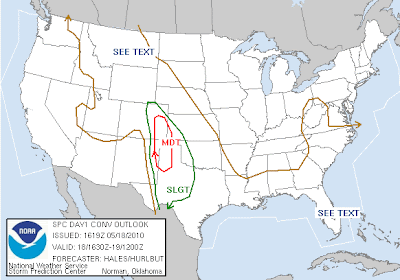
Chasing in our backyard today, looks like we have a chance for large hail and isolated tornadoes in our area. Will be out chasing today on the northeast of our plains.. Hard play today, just got to keep an eye on breaks in the clouds and watch radar, for the areas of the best cape and shear. I still like the Cheyenne Ridge today.
Monday, May 24, 2010
Sunday, May 23, 2010
Target area today
Saturday, May 22, 2010
May 22 2010
Friday, May 21, 2010
May 21 2010

(South of Lusk, WY 6:45pm)
 (Near Crawford, at 7:30 pm)
After the sun went down, and some beers with TIV crew, we went back out around Chadron, NE watching a very incredible lightning storm, and a very very low meso on what seemed to be a nicely structured storm. Staying the night in Chadron, NE tonight to position ourselves for South Dakota.

Chasing with Becca, briefing with Chris Yates at 12:30pm today... Going to be a fun chase around the Cheyenne Ridge area...
Tuesday, May 18, 2010
May 18th 2010
(Neat Striations and CG's out of this cell west of Fort Morgan, CO)
Monday, May 17, 2010
May 16th 2010
May 15th 2010
Sunday, May 9, 2010
High Risk 30 percent torn
Sunday, May 2, 2010
Saturday, May 1, 2010
May 1st 2010
Brandon Ivey and Byron Turk Today

Governor Declared A State of Emergency
Looks like a very intense day for Arkansas. There are very violent tornadoes today.. With 90 over 70 earlier, and the very intense vertical wind shear, high supply of moisture, theres a chance of long track tornadoes into the night. I saw a posting on facebook by Mike Umscheid of spotter locations according to the radar and thought its ridiculous. There are a lot of "storm chasers" out there now, and yet they continue to risk their lives.

As much as I like to watch the weather channel, maybe now or tomorrow would be a good time to watch it or cnbc, or something to see what happened to the people in this state. These were very strong tornadoes. And there still is a dangerous situation unfolding tonight.
You can see storm reports at www.spc.noaa.gov

Governor Declared A State of Emergency
Looks like a very intense day for Arkansas. There are very violent tornadoes today.. With 90 over 70 earlier, and the very intense vertical wind shear, high supply of moisture, theres a chance of long track tornadoes into the night. I saw a posting on facebook by Mike Umscheid of spotter locations according to the radar and thought its ridiculous. There are a lot of "storm chasers" out there now, and yet they continue to risk their lives.

As much as I like to watch the weather channel, maybe now or tomorrow would be a good time to watch it or cnbc, or something to see what happened to the people in this state. These were very strong tornadoes. And there still is a dangerous situation unfolding tonight.
You can see storm reports at www.spc.noaa.gov
Subscribe to:
Comments (Atom)


