Thursday, November 18, 2010

Cold blasting gust front - Greeley, CO

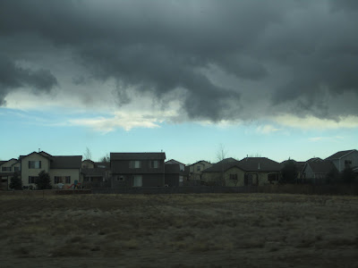
Tuesday I left the house it felt about 55 degrees and felt warm and calm, I drove about 5 blocks noticing the clouds looking convective and intense. Very quickly it dropped what felt about almost 20 degrees and the winds were gusting an estimated 35 Knots. I took some pics of the convectiveness and the defined boundary and skinner archived these radar and sat for me after i texted him about it. You can see the crazy front on radar and what looks to even be some 35 dbz in there, possibly just some heavier rain, as it was raining. Later that evening it started to rain pretty hard and then sleet.

In the pics below you can see that the base of the clouds is defined in some, I was watching strong rising motion!, and also what sort of resembles mammatas clouds




Tuesday, August 10, 2010

Largest Hailstone


(The new Record Holder from Vivian, SD on July 23rd 2010 on the left (Actual Hailstone), and the replica of the old record holder from Coffeyville, KS on the right)

Today I had the privilege to go down to Boulder at UCAR to see the Largest Hailstone in US History and could be the largest in Recorded World History. Thanks to Becca, and her friends in her line of work we were able to see this hailstone before it goes back to the owner for sale on ebay. We also got to see the replica of the Coffeyville, KS hailstone which was the previous record holder to the Aurora, NE hailstone, which we got to see slices of.

(Radar Image of the Vivian, SD Cell)

Saturday, August 7, 2010

Boundary Action


A nice looking boundary this afternoon left over from yesterday's storms, taken from Nunn, CO (see August 6th chase)

Saturday, July 24, 2010

Recap

Check back in a couple weeks, I will start recapping the season with more video and picks. I have found it hard to keep up the blog this year but some interesting footage will come soon.

Sunday, July 4, 2010

Independence Day Chase


Flooding in Kimball


Video coming soon


I know its been a while since my last posting, I will post more of what happened in June soon. I was out of my computer for a while. Today was great with my chase in Wyoming and Nebraska. Had tornado warnings out all over the place, when I saw the RUC at 5am this morning I said woah today is going to be epic, and that wasnt far from the truth. With as many supercells and tornado warnings as there were. I saw a possible large tornado near Chugwater, WY earlier in the day. I say possible because the bluffs were in the way and I could only see the top of what seemed to be a stovepipe tornado. I chased the second cell accross Hwy 313 to 85 and ran into Verne Carlson. From there we watched for a bit until outflow killed it. Then went south to the cell that developed northeast of Cheyenne. Once we got really close verne and I outside the car caught a rapidly developing funnel, and then it touched down on the ground for a brief time. With Becca on my text chat on the comp, and her as coordinator and then operating radar, I was able to deliver fast and detailed reports which helped out with accurate warnings. After the breif tornado, decided to punch the big white reflectivity on radar to see what the hail would bring. I got golf ball hail, I imagine it was probably bigger just a bit earlier in the storm cycle.

My SPC Torn Report
2309
7 N BUSHNELL KIMBALL NE413310389 SPOTTER REPORTED TORNADO ON GROUND FOR ABOUT 30 SECONDS.

Thursday, May 27, 2010

Wednesday, May 26, 2010

Backyard Chasing May 26

Chasing in our backyard today, looks like we have a chance for large hail and isolated tornadoes in our area. Will be out chasing today on the northeast of our plains.. Hard play today, just got to keep an eye on breaks in the clouds and watch radar, for the areas of the best cape and shear. I still like the Cheyenne Ridge today.

Sunday, May 23, 2010

Target area today

Targeting Oakley, KS area for initiation today, and surrounding area for best Helicity and Cape. The RUC Composite shows development starting at 6pm CDT around Oakley. Waiting for this cu field to move westward in Wakeeney right now while checking models, then break cap in a couple hours.

Saturday, May 22, 2010

May 22 2010


Chasing in Becca's favorite territory today! Except for the area near NE/SD border which is horrible territory. Which happens to look the best on the models.. It also seems that a nice cell in the Texas panhandle may occur today.. :)

Friday, May 21, 2010

May 21 2010


(Just before the tornado west of wheatland, wy)

(Reported as a Tornado, near Wheatland, WY)


(Near Jay Em, WY found at 6:30pm)


(South of Lusk, WY 6:45pm)

(Near Crawford, at 7:30 pm)

After the sun went down, and some beers with TIV crew, we went back out around Chadron, NE watching a very incredible lightning storm, and a very very low meso on what seemed to be a nicely structured storm. Staying the night in Chadron, NE tonight to position ourselves for South Dakota.


Chasing with Becca, briefing with Chris Yates at 12:30pm today... Going to be a fun chase around the Cheyenne Ridge area...

Tuesday, May 18, 2010

May 18th 2010

(Where my chase started out over south Denver, lots of tight circulation)


(Neat Striations and CG's out of this cell west of Fort Morgan, CO)


Moderate Risk and 10% tornado in Colorado today!

Monday, May 17, 2010

May 16th 2010

What a great day, was some of the best daytime cc and cg lightning i have seen in a while, got to see a bell shaped meso, and a rotating wall cloud in front of a sunset. On the way home I saw a meteor break through a good portion of the atmosphere too! Chased from Wiggins to Fort Morgan area.


May 15th 2010


This cell (top 2 pics) west of Cheyenne produced a Tornado Early Afternoon, crazy low topped cells with lots of convergence and boundary action

Lots of hail north of Kersey, CO


Nice CG northwest of Sterling, CO after watching a funnel and nice storm structure on this cell