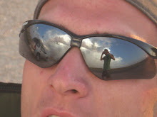
This chase was perfect, I didnt even expect to go on this chase. I was hanging out just keeping an eye on the weather. Around 4pm I decided to head out to these high based cells that were forming off the Cheyenne ridge and headed southeast to the east of Greeley. I went out and just sat under high based storms knowing they would move into higher dew points. These cells converged and created a beautiful super cell. Skinner was my now caster/navigator from the hospital, he had to navigate to a pin point for me because the RFD and Tornado was on my bumper!! I stayed in front of it from wiggins where I got tennisball size hail and then I got caught in the RFD where 70-80mph winds almost tipped my car. I then headed south southeast to work my way to Agate, CO where 9 news took these pictures and Cory Green ran into me where he rode the rest of the storm chase out with me. We paralleled the storm from limon southeast to a rest stop where the tornado warning expired so we waited for the hail core to pass over us. I got my helmet and goggles on and walked around in the hail. It was pretty funny cause Roger Hill's tour group was parked next to us, I bet they said hes crazy! It was great because I was always in the right spot at the right time, thanks to skinner as well. He saved my life a couple times! Skinner is editing the video right now so it should be up on here soon, keep checking!

 This chase was perfect, I didnt even expect to go on this chase. I was hanging out just keeping an eye on the weather. Around 4pm I decided to head out to these high based cells that were forming off the Cheyenne ridge and headed southeast to the east of Greeley. I went out and just sat under high based storms knowing they would move into higher dew points. These cells converged and created a beautiful super cell. Skinner was my now caster/navigator from the hospital, he had to navigate to a pin point for me because the RFD and Tornado was on my bumper!! I stayed in front of it from wiggins where I got tennisball size hail and then I got caught in the RFD where 70-80mph winds almost tipped my car. I then headed south southeast to work my way to Agate, CO where 9 news took these pictures and Cory Green ran into me where he rode the rest of the storm chase out with me. We paralleled the storm from limon southeast to a rest stop where the tornado warning expired so we waited for the hail core to pass over us. I got my helmet and goggles on and walked around in the hail. It was pretty funny cause Roger Hill's tour group was parked next to us, I bet they said hes crazy! It was great because I was always in the right spot at the right time, thanks to skinner as well. He saved my life a couple times! Skinner is editing the video right now so it should be up on here soon, keep checking!